Øresund Bridge Guide: How to Cross It, See It and Understand It
How do you cross the Øresund Bridge and how much does it cost?
By train (Øresundståg): 35–40 minutes from Copenhagen Central Station to Malmö, approximately 100–150 DKK one way. The train is the simplest option — no tolls, no queues, and you cross the above-water section in about 8 minutes with full views. By car: the toll is 430 DKK (one way) for a standard car at the Danish approach. You drive across the bridge and through the Drogden Tunnel on the Danish side.
The Øresund Bridge is one of the most significant pieces of infrastructure in northern Europe. It connects two countries, two capital regions (Copenhagen and Malmö/Skåne), and was completed in 2000 after decades of political negotiation. For visitors, it is both a transit route and a landmark — crossing it by train is genuinely memorable, particularly when you emerge from the tunnel section onto the open-water bridge and the cable-stayed pylon fills the window.
This guide explains how the structure works, how to cross it, how to see it from land, and the practicalities of the car toll.
What the Øresund Fixed Link actually is
Most people call it “the bridge,” but the Øresund Fixed Link is more complex:
1. Drogden Tunnel (Denmark): A 4 km immersed tube tunnel running from the Copenhagen Airport/Kastrup area beneath the Øresund strait to an artificial island called Peberholm. This section is completely underground and invisible from the surface. The tunnel was built as an immersed tube — sections were fabricated in a dry dock and sunk into a prepared trench on the seabed.
2. Peberholm (artificial island): A 4 km long artificial island created with material excavated from the tunnel. It connects the tunnel to the bridge. Peberholm is now a nature reserve — the artificial environment has attracted plants and animals colonizing naturally. It is not accessible to the public.
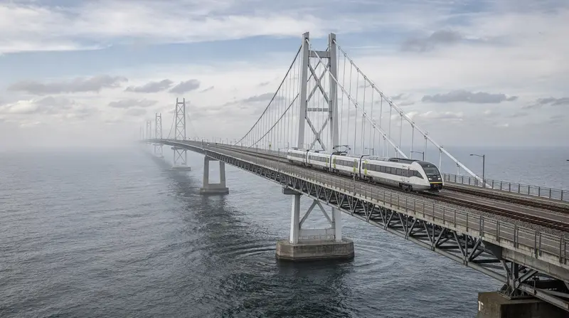
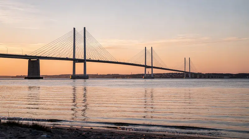
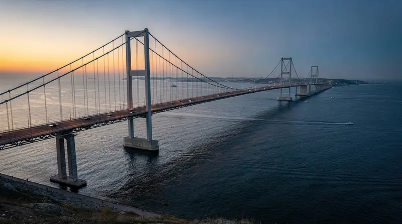
3. The Øresund Bridge (cable-stayed span): 7.8 km of bridge from Peberholm to the Swedish coast at Lernacken, near Malmö. The bridge carries two road lanes in each direction on the upper level and two railway tracks on the lower level (rail and road share the same structure on different decks). The central section is a cable-stayed span with a single pylon at 204 meters height and a clearance of 57 meters above sea level at the highest navigable point.
The bridge is not elevated along its entire length — the western sections taper down toward Peberholm and the eastern sections toward the Swedish coast. The cable-stayed center section is the iconic element visible in photographs and in the TV show.
Crossing by train
The Øresundståg (Øresund Train) crosses the bridge on the lower deck of the cable-stayed section, and through the Drogden Tunnel on the Danish approach. The journey experience from Copenhagen Central Station:
Departing Central Station: The train moves east through the city, stopping at the airport (where you emerge above ground). After the airport, the train enters the Drogden Tunnel — the lights dim, pressure changes slightly, you are briefly underwater for about 7–8 minutes.
Peberholm and the bridge: The train emerges from the tunnel onto Peberholm (you see flat land briefly, the island is narrow). Then the bridge begins — you rise, open water appears on both sides, the pylon is visible ahead. The full above-water crossing takes approximately 8 minutes.
Arriving in Sweden: The bridge descends toward the Swedish coast. The train passes through Hyllie station (a major Swedish suburb development near the bridge) and then arrives at Malmö Central Station.
The view: For the best views of the cable-stayed section and the water:
- Sit on the right side of the train (traveling from Copenhagen toward Malmö) — you face south, looking out across the open Øresund strait
- Either side gives open-water views, but the cable-stayed pylon is slightly better appreciated from the right
Cost and logistics: See the Copenhagen to Malmö train guide for pricing, ID requirements and timetable details. For all transport options within Copenhagen itself, see getting around Copenhagen.
A guided tour across the Øresund Bridge to Lund and Malmö combines the bridge crossing experience with structured visits to both Swedish cities — including context on why the bridge was built and what the Øresund Region means today.Crossing by car
The toll (BroPas / standard payment):
| Vehicle type | One-way (DKK) | Approximate € | |---|---|---| | Car under 6m | 430 DKK | ~57€ | | Motorcycle | ~215 DKK | ~28€ | | Car over 6m (e.g., with trailer) | Higher rate | — | | Truck | Variable | — |
Prices are approximate and subject to adjustment. A same-day or 48-hour return is slightly discounted compared to two separate one-way tolls. Payment is at the toll plaza by card (contactless accepted at most lanes) or via BroPas (a pre-paid transponder for frequent users — not relevant for tourists).
From Copenhagen: Take the E20 motorway from central Copenhagen south toward the airport (see the Copenhagen Airport guide for the airport approach), then follow signs to the Øresund Bridge. The toll plaza (Kastrup) is on the Danish side before the tunnel entrance.
From Malmö (returning): The Swedish toll plaza is at Lernacken, on the Swedish approach to the bridge. Same payment process.
Journey time by car: The bridge crossing itself takes about 10–15 minutes. Combined with the tunnel section, the full crossing (Danish toll plaza to Swedish coast) takes approximately 20–25 minutes. Add city transit time at each end.
Driving on the bridge: Standard European driving — right-hand traffic on the road deck. The maximum speed on the bridge is 90 km/h (sometimes reduced to 80 km/h in strong crosswinds). The bridge is occasionally closed or speed-reduced in severe weather — high winds are the main closure cause.
Parking in Malmö: Paid street parking and car parks. Central Malmö parking costs approximately 20–35 SEK per hour. Several car parks near the station and the old town.
Renting a car: If you are renting a car in Denmark and plan to drive to Sweden, verify with the rental company that cross-border travel is included in your agreement. Most major rental companies (Hertz, Avis, Budget) permit this with advance notice, but it must be noted in the contract.
Seeing the bridge from land (without crossing)
Both the Danish and Swedish shores offer land-based views of the bridge. Neither provides the full experience of a crossing, but they are free and accessible.
From Copenhagen/Amager (Danish side)
Amager Strandpark: A 4.6 km beach park on Amager, south of central Copenhagen. Take the Metro M2 to Amager Strand station (5 stations south of Kongens Nytorv, approximately 6 minutes). Walk east to the beach — the bridge is clearly visible approximately 5–6 km to the south. The view is from the side, so the cable-stayed pylon is visible in profile. Best visibility in clear weather; can be obscured in mist. The beach is a legitimate destination in its own right in summer (swimming, café, windsurfing).
Kastrup area (near the airport): The coastal area just north of the toll plaza has industrial infrastructure and limited scenic access. Not recommended as a viewpoint.
From Malmö (Swedish side)
Ribersborg: A beach and promenade area west of Malmö center (20–25 minutes on foot from the Central Station, or 10 minutes by bus). Looking east from Ribersborg, the Øresund Bridge is directly in the sightline — the cable-stayed section is more visible from here than from any other land-based point. The view includes the bridge and the pylon, with the bridge appearing to stretch away toward Denmark.
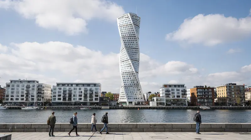
Västra Hamnen (Western Harbor): The modern Malmö waterfront district. From the harbor promenade, looking west and north, the bridge is visible at an angle. The Turning Torso tower is also here. A good combination: photograph the bridge and the Turning Torso in the same afternoon.
The bridge and “The Bridge” (Broen/Bryggan)
The Øresund Bridge became internationally known through the Nordic noir TV series Broen (Danish) / Bryggan (Swedish), co-produced by DR (Denmark) and SVT (Sweden), first broadcast in 2011. The opening scene — a body found precisely on the mid-bridge border, triggering a joint Danish-Swedish investigation — established the bridge as a visual and narrative anchor.
The actual filming used the real bridge (drone shots, exteriors) and real locations in Copenhagen and Malmö. The police stations shown are fictional composites, but the neighborhoods and streets are real.
For viewers of the series, the train crossing is particularly resonant — you cross the same structure, see the same cable-stayed pylon, arrive at the same Malmö Central Station. The show brought a significant increase in Danish-Swedish tourism and is still referenced by visitors who book the crossing specifically because of it.
The Øresund Region: why this bridge matters beyond tourism
The Øresund Bridge was built as an economic and political project, not a tourist attraction. The concept of an “Øresund Region” — treating the greater Copenhagen area and southern Sweden (Skåne) as a single metropolitan labor and housing market — was the political goal. In practice:
- Approximately 18,000–22,000 workers cross the bridge daily by train, most of them Swedes who live in Malmö or Skåne and work in Copenhagen (or vice versa)
- The bridge handles roughly 14,000–16,000 cars per day
- Malmö’s population growth since 2000 has been partly attributed to its role as a more affordable place to live within commuting distance of Copenhagen
The total construction cost was approximately 30 billion DKK (around 4 billion euros at 2000 exchange rates). The bridge is operated by Sund & Bælt, a Danish company. It has been profitable from tolls since around 2019 — sooner than originally projected.
Practical tips for crossing
Train is almost always better than car: Unless you specifically need a car in Sweden, the train is faster, cheaper, and less stressful than driving and paying the 430 DKK toll.
Check weather: The bridge closes or reduces speed in high winds. Strong westerly storms (autumn/winter) occasionally cause temporary closures. Check the Øresundsbron traffic updates (oeresundsbron.com) if you are driving. Train service is less affected than road traffic.
Peak times: Friday afternoon/evening (Swedes returning from Copenhagen week) and Sunday evening (returning the other direction) are the busiest crossing times. The train can be crowded; the road toll plaza has longer queues.
Photography on the bridge: The best positions for photographing the cable-stayed section from the train are the windows on the south-facing side (right side traveling toward Malmö). The pylon comes into frame and then passes overhead. The light is best in morning hours (the pylon catches light from the east).
Frequently asked questions about the Øresund Bridge
Has the Øresund Bridge ever closed?
Yes, occasionally due to severe weather — primarily high winds exceeding approximately 25–30 m/s. Road traffic is more vulnerable to wind closures than the rail service, which can operate in higher winds due to lower air resistance of the rail profile. Ice is managed by de-icing systems and has not been a significant closure cause. The bridge has never been structurally compromised.
Is the Øresund Bridge toll included in anything?
No. The toll is charged per crossing regardless of any tourism cards, railway passes or other discount programs. Eurail passes cover train travel on the Øresundståg (check your specific pass for Danish and Swedish coverage), but the toll applies to car crossings only and is separate from any pass system.
What is Peberholm?
Peberholm (literally “Pepper Island” in Danish) is a 4 km artificial island created from material excavated during the construction of the Drogden Tunnel. It was named as a counterpart to the nearby natural island of Saltholm (“Salt Island”). No one lives on Peberholm; it has become an involuntary nature reserve with pioneer species colonizing since 2000 — hares, birds, and various plant species. It is closed to the public.
Can I see the bridge from an airplane?
Yes. Flights approaching or departing from Copenhagen Airport often pass near or over the Øresund strait. Window seats on the south or east sides of the aircraft (depending on departure direction) may give views of the bridge. The approach to runway 22L from the north passes almost directly over the bridge approach.
What happened to the ferries that used to connect Copenhagen and Malmö?
The Copenhagen-Malmö ferry route (operated by several companies over the years) was discontinued when the bridge opened in 2000. Journey times by ferry were approximately 45–60 minutes. The bridge and train have made the ferry economically unviable. Some commentators have noted the environmental trade-off: the bridge generates more road traffic than the ferry did, but the train component is significantly lower-emission than either ferries or car crossings.
Frequently asked questions — Øresund Bridge Guide: How to Cross It, See It and Understand It
How much is the Øresund Bridge toll for cars?
The standard one-way toll for a car (under 6m) is approximately 430 DKK (approximately 57€) paid at the Danish toll plaza (Kastrup) or the Swedish toll plaza (Lernacken). Return same-day or within 48 hours: approximately 810 DKK. Motorcycles: lower rate. Trucks and higher vehicles pay significantly more. Payment by card at the toll booth. Bropas frequent-user card gives a discount — not relevant for one-time tourist crossings.What is the difference between the bridge and the tunnel sections?
The Øresund Fixed Link consists of two main sections: a 4 km underwater tunnel (from Copenhagen Airport area to Peberholm, an artificial island) and an 8 km bridge (from Peberholm to the Swedish coast near Malmö). Car drivers pass through both sections. Train passengers also use both, but the scenic experience — open water views and the cable-stayed pylon — happens on the 8 km bridge section.Can I walk or cycle across the Øresund Bridge?
No. The Øresund Bridge has no pedestrian or cycle path. Crossing on foot or by bicycle is not possible. You must cross by train or car (or in a vehicle). Ferries between Copenhagen and Malmö were discontinued when the bridge opened in 2000.Where is the best place to see the Øresund Bridge from land?
From Copenhagen: Amager Strandpark (the beach park south of the city, reachable by Metro M2 to Amager Strand station) offers a clear view of the bridge from the Danish side. From Malmö: Ribersborg beach (west of Malmö center, 20–25 min walk from Central Station) gives a direct view of the bridge from the Swedish approach. The bridge is also visible from Malmö's Västra Hamnen harbor district.Why was the Øresund Bridge built?
The Øresund Bridge opened in July 2000 to create a fixed transport link between Denmark and Sweden — replacing the ferries that had previously operated on the route. The project was designed to create an integrated cross-border region (the Øresund Region) combining the Greater Copenhagen area with Malmö and Skåne in Sweden. It was controversial during construction due to environmental concerns but is now accepted as a regional economic anchor.How long is the Øresund Bridge?
The Øresund Bridge itself (the above-water section) is 7.8 km long. Including the Drogden Tunnel (4.05 km) and the artificial island Peberholm in between, the total Øresund Fixed Link is approximately 16 km. The cable-stayed section — the recognizable iconic span — is 1,092 meters with a central pylon of 204 meters height.Is the Øresund Bridge related to the TV show 'The Bridge'?
Yes. The Danish-Swedish crime drama 'Broen/Bryggan' (The Bridge, 2011–2018) was named after and used the Øresund Bridge as a central plot device — a body found on the mid-bridge border between Denmark and Sweden triggers the cross-border detective investigation. The show used the actual bridge and real locations in both Copenhagen and Malmö. It significantly increased tourism interest in the bridge and is still referenced by visitors.