Copenhagen Cycling Routes: The Best Rides for Visitors
Copenhagen: Highlights 3-Hour Bike Tour with a Local Guide
Duration: 3 hours
What is the best cycling route in Copenhagen?
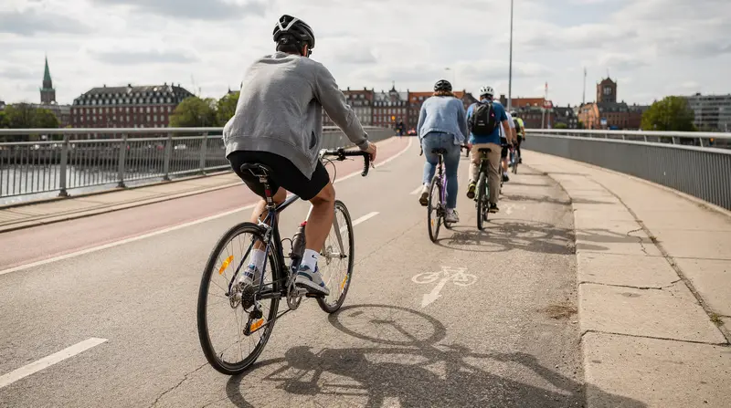
The Harbour Ring (Havneringen) is the most rewarding urban cycling route — a roughly 13 km loop around the inner harbour that connects Nyhavn, Christianshavn, Islands Brygge, and the inner city waterfront. It is entirely on dedicated infrastructure, well-signed, and passes or connects to most of the city's main water landmarks. Suitable for all fitness levels; allow 1–2 hours depending on pace and stops.
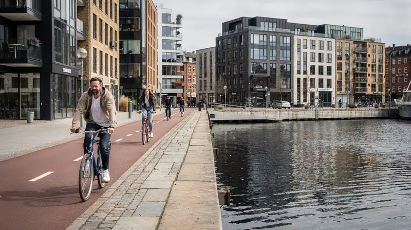
Copenhagen’s cycling infrastructure: what makes it different
Copenhagen does not have cycling routes. It has a cycling network. The distinction matters: a cycling route implies a designated path designed primarily for recreation; a cycling network implies that the entire city is connected by dedicated cycling infrastructure, and you can get from any point to any other point by bike without significant routing difficulty.
For visitors, this is genuinely useful. Unlike cycle-touring in rural areas where you must plan carefully to stay on marked paths, cycling in Copenhagen requires very little navigation — the cycle lanes are on nearly every main street, the signage is clear, and the infrastructure connects naturally.
The routes below are not just recreational loops. Most of them can be used as transport (to get from one part of the city to another) as well as for sightseeing. Each can be extended or shortened depending on your time and interest.
Route 1: The Harbour Ring (Havneringen) — recommended start
Distance: ~13 km for the full loop.
Time: 1.5–2.5 hours depending on stops.
Difficulty: Easy. Flat throughout.
Infrastructure: Mostly dedicated cycle lanes; some shared zones near Nyhavn.
The Harbour Ring is an official city cycling route that loops around the inner harbour, connecting the waterfront on both sides. It is the most scenically rewarding urban cycling route in the city and the natural starting point for any visitor cycling Copenhagen.
Route description (starting from Kongens Nytorv / Nyhavn):
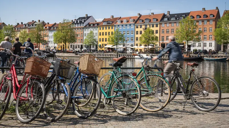
Start at Kongens Nytorv and cycle toward the Nyhavn canal. Ride along the north quayside of Nyhavn (south side is pedestrian-dominated; north side has the cycle lane). Continue east to the Amalienborg waterfront, with views across the harbour to the Opera House.
Continue north along the Langelinie waterfront — this section has views of the Little Mermaid on your right (you will see where to dismount and walk to her rock if you want), and continues past the Citadel (Kastellet). Note: Kastellet itself is a star-shaped fortress with internal roads — worth a quick detour inside.
Turn south and cross the inner harbour on the Inderhavnsbroen (the harbour bridge) — a dedicated pedestrian and cycle bridge with excellent views back toward Nyhavn and toward the Opera House. This bridge is one of the city’s best photo spots.
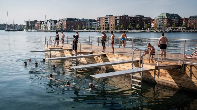
Continue south along Christianshavn’s waterfront and the Islands Brygge harbourfront. Islands Brygge is worth a stop — the harbour bath, the park, and the views back to the city centre.
Cross the harbour back north on Langebro (Langebro bridge has a dedicated cycle lane and a long elevated view of the inner harbour).
Return to the city centre via Vester Voldgade and Rådhuspladsen (City Hall Square) area.
What you see on this route: Little Mermaid, Kastellet, Inderhavnsbroen, Opera House views, Christianshavn, Islands Brygge harbour bath, harbour baths, Nyhavn.
Where to stop: Islands Brygge harbour bath (free swimming in summer), Nyhavn for coffee, Langelinie for views.
Route 2: The Lakes Circuit (Søerne)
Distance: 6–8 km for the lakes circuit; 12–16 km if extended into Nørrebro and Frederiksberg.
Time: 45–90 minutes for the basic circuit.
Difficulty: Easy. Almost entirely car-free or on light-traffic streets.
Infrastructure: Dedicated cycle path alongside the lakes; residential streets elsewhere.
Copenhagen’s three connected lakes — Sortedams Sø, Peblinge Sø, and Sankt Jørgens Sø — form a natural green corridor along the boundary between the old city centre and the 19th-century expansion districts. The cycle path running the length of the lakes is separate from both the road and the pedestrian path, making it one of the most relaxed cycling environments in the city.
Route description:
Start at Dronning Louises Bro (the bridge between Nørrebro and the Indre By) — one of Copenhagen’s busiest and most photographed crossings. Cycle south along the lake path, past the rowing clubs and the willows, through the residential neighbourhood boundary to the bottom of Sankt Jørgens Sø.
From there, either:
- Loop back north along the western bank to the starting bridge (basic 6 km circuit)
- Continue west into Frederiksberg (the independent municipality at the heart of Copenhagen) via Vodroffsvej and the Frederiksberg Gardens
- Extend north into Nørrebro via Nørrebrogade (Copenhagen’s most-cycled road)
What you see: Waterfowl, rowing clubs, the distinct architecture of the late-19th-century apartment buildings along the lake banks, views to the towers of Indre By. On warm days, the lakeside paths are packed with runners, cyclists, and picnickers — this is Copenhagen living rather than tourist-managed Copenhagen.
Nørrebro extension: Cycling north on Nørrebrogade from the lake takes you through Copenhagen’s most culturally diverse and politically active neighbourhood. The Assistens cemetery (where Kierkegaard and H.C. Andersen are buried) is on the left; the food market, cafés, and street art of Nørrebro continue for 2 km north. This is the neighbourhood that represents contemporary Copenhagen more than the tourist-managed Nyhavn area.
Route 3: Amager Strand and Amager Fælled
Distance: 15–25 km one way depending on starting point and how far along Amager you cycle.
Time: 2–4 hours for the full Amager coastal route.
Difficulty: Easy. Flat throughout.
Infrastructure: Dedicated cycle lanes through Christianshavn into Amager; coastal path along Amager Strand is car-free.
Amager is the large island southeast of the city centre, connected to the historic city by several bridges and by the metro (M2 line, underground through the island). The cycling route from the city centre through Christianshavn and into Amager is a classic Copenhagen local ride — down Amagerbrogade (a wide street with dedicated cycle lanes), into the nature reserve of Amager Fælled (a marshland and meadow reserve within metro distance of the city centre), and along the coastline to Amager Strand.
Route description:
From Kongens Nytorv, cross to Christianshavn (Knippelsbro bridge has a cycle lane) and continue south on Amagerbrogade. After 2–3 km, turn east into Amager Fælled — the nature reserve is signed and the main cycle paths through it are clear.
Amager Fælled has:
- Open meadows used as a local dog-walking and picnic area
- The CopenHill artificial ski slope and running hill (visible from the cycle path)
- The Amager Resource Center — the waste-to-energy plant with a hiking trail on its roof (accessible to visitors)
Continue east from Amager Fælled to the Amager Strand coast — a constructed artificial beach with a lagoon, a long sandy strip, and views across the Øresund to Sweden (Malmö is visible on a clear day).
The Amager Strand coastal path runs for approximately 4.5 km along the beach. Cycling is permitted on the main coastal path; the beach itself is pedestrian only. The water in the lagoon is calmer and warmer than the harbour — popular for summer swimming.
Good extension: The path continues south along the coast to Dragør, a preserved 18th-century fishing village (see the Dragør day trip page for more). The full city centre to Dragør cycling distance is approximately 18–20 km — a satisfying half-day ride.
Route 4: The Inner City Circuit
Distance: 8–12 km depending on diversions.
Time: 1.5–2.5 hours with stops.
Difficulty: Easy, but requires more lane navigation than the other routes.
Infrastructure: Dedicated cycle lanes throughout; higher traffic density than the harbour or lake routes.
A loop through the major sights of the inner city that is efficient enough to be a genuine city orientation by bike rather than just a pleasant ride.
Route description:
Start at Rådhuspladsen (City Hall Square). Cycle through Strøget area (pedestrianised — walk the bike, or take the cycle lanes on parallel streets). North on Bredgade to Amalienborg Palace and the Marble Church. East to Nyhavn. North along the harbour to Kastellet. West back through Indre By via Kongens Nytorv and Gothersgade, passing Rosenborg Castle (short stop for the gardens). South through the Latin Quarter back to Rådhuspladsen.
What you see: City Hall, Strøget shopping street, Amalienborg, Nyhavn, Kastellet, Rosenborg Castle and the King’s Garden. This is the densest concentration of major tourist landmarks in a single cycling route.
Note on Strøget: The pedestrianised section of Strøget (from Rådhuspladsen to Kongens Nytorv) does not permit cycling — walk the bike or use parallel cycling streets (Gammel Kongevej to the south, or Bredgade to the north). Getting caught cycling in the pedestrian zone will result in a polite but firm request from nearby Copenhageners to stop.
Route 5: Dyrehaven (the Deer Park)
Distance: 8–15 km within the park; 12–15 km from Østerbro to the park entrance one way.
Time: Half-day including transit or cycling to/from the park.
Difficulty: Easy to moderate (unpaved forest paths within the park; paved from the city).
Infrastructure: Paved cycle lanes to the park entrance; unpaved forest tracks within.
Dyrehaven is a royal deer park 10 km north of Copenhagen city centre. The park covers approximately 11 km² of ancient forest, grassland, and the oldest deer population in Denmark (around 2,000 fallow deer roam freely). It is one of the most genuinely beautiful natural areas within reach of the city.
Getting there by bike: Cycle north from Kongens Nytorv via Østerbrogade, continuing on the coastal cycle route through Hellerup and Charlottenlund to the park entrance near Klampenborg. Total distance: 12–15 km, 1–1.5 hours. The route follows the cycle lane along the coast with views of the Øresund — pleasant but exposed to wind.
Getting there by S-train: Take the S-train (line A or B) to Klampenborg (22 minutes from Nørreport with a bicycle supplement ticket of 15 DKK). Rent a bike near the station or cycle within the park on foot.
Within the park: Dyrehaven has an internal road network used by cyclists and walkers. No cars except for official vehicles. You can cycle to the Hermitage Palace (a royal hunting lodge in the centre of the park), through the forest deer zones, and down to the Bellevue Beach at the park’s coastal edge.
3-hour extended grand e-bike guided tour (includes Dyrehaven areas) private Copenhagen e-bike history and nature tourGuided e-bike tours that extend into the northern coastal areas and Dyrehaven provide context on the park’s history as a royal hunting ground and its current role as a UNESCO-recognised cultural landscape.
Practical route planning
Best app for Copenhagen cycling: Google Maps has reliable Copenhagen cycle route data. Komoot is better for longer routes that leave the city infrastructure. The Rejseplanen app includes cycling as a mode of transport.
Signage: Copenhagen’s official cycling routes are signed with numbered markers (Route 9, Route 12, etc.) and directional signs on wooden posts. The harbour ring (Havneringen) is specifically signed throughout its length.
Avoiding peak times: The busiest cycling times on major lanes are 07:30–09:00 and 16:00–18:00 on weekdays. If you are unfamiliar with the lanes, these times are more challenging for tourist cyclists. Midday and weekend mornings are the most comfortable.
Starting points by area:
- Inner city routes: start at Kongens Nytorv (M1/M2 metro)
- Harbour ring: start at Nyhavn or Gammel Strand
- Lakes circuit: start at Nørreport (S-train/Metro hub)
- Amager routes: start at Christianshavn (M1/M2 metro)
- Dyrehaven: start at Klampenborg (S-train line A or B)
Frequently asked questions about Copenhagen cycling routes
Is Copenhagen flat enough to cycle easily?
Yes. Essentially no meaningful hills within the city. All routes below are suitable for casual cyclists.
How long does it take to cycle the harbour ring?
At a tourist pace with stops: 1.5–2.5 hours. The full loop is approximately 13 km.
Can I cycle to Dyrehaven from central Copenhagen?
Yes, approximately 12–15 km one way on dedicated cycle infrastructure. Alternatively, take the S-train to Klampenborg (20 minutes) with a 15 DKK bicycle supplement.
Where can I cycle in Copenhagen without traffic?
The Søerne (lakes) path, the Amager Fælled nature reserve, and Dyrehaven are all car-free or near car-free. The inner harbour paths are largely separated from traffic.
Are there cycling maps available?
Yes. The Cykelkortet (Copenhagen cycling map) is free from tourist offices and many hotels. Also available via the Cycling Copenhagen app and Google Maps.
Can I cycle to Malmö (Sweden) from Copenhagen?
You cannot cross the Øresund Bridge by bike. Take the train with a bicycle supplement (approximately 15 DKK) from Copenhagen Central Station to Malmö, then cycle within Malmö.
What cycle route goes through Nyhavn?
The harbour ring route and the inner city circuit both pass through or alongside Nyhavn. The quayside itself is shared with pedestrians — ride slowly and give way.
Frequently asked questions — Copenhagen Cycling Routes: The Best Rides for Visitors
Is Copenhagen flat enough to cycle easily?
Yes. Copenhagen is almost entirely flat — there are no meaningful hills within the city or on the routes below. The slight inclines on bridges (Langebro, Knippelsbro) are gentle and brief. Any fitness level that can walk for 2 hours can cycle the harbour ring or the lakes circuit without significant effort. E-bikes are available but genuinely unnecessary for most of these routes.How long does it take to cycle the harbour ring in Copenhagen?
At a tourist pace with brief stops, the Harbour Ring (approximately 13 km) takes 1.5–2 hours. Cycling faster without stops: around 45–60 minutes. Plan 2.5–3 hours if you want to stop at Islands Brygge, take photos at Nyhavn, or visit any of the landmarks along the route.Can I cycle to Dyrehaven (the deer park) from central Copenhagen?
Yes. The cycling distance from central Copenhagen to Dyrehaven is approximately 12–15 km one way, following the coastal route north via Østerbro and Hellerup. The route is largely on dedicated cycle infrastructure. Round trip: 24–30 km, 2.5–3.5 hours cycling time. Alternatively, the S-train to Klampenborg station takes 20 minutes and eliminates the ride north entirely — cycle within the park (you can hire bikes near the station) or combine train north with a cycling return along the coast.Where can I cycle in Copenhagen without traffic?
The Søerne (the lakes) cycle and running path is car-free. The harbour ring along Islands Brygge and the inner harbour is largely car-free or has fully separated infrastructure. Amager Fælled (nature reserve on Amager island) has dedicated cycle paths through a near-urban nature area. Frederiksberg Gardens has a car-free internal path. Dyrehaven is entirely car-free (it is a royal deer park).Are there cycling maps available in Copenhagen?
Yes. The Copenhagen cycling map (Cykelkortet) is available free from the city's tourist offices and some hotels. The city also produces a digital version via the Rejseplanen app and the Cycling Copenhagen app. Google Maps and Komoot both have reasonably accurate cycling route data for Copenhagen. Most rental shops provide a basic route overview.Can I cycle to Malmö (Sweden) from Copenhagen?
You can cycle to the Øresund Bridge but not across it — the bridge is closed to cyclists and pedestrians. The standard route is to take your bike on the train across the Øresund (approximately 35 minutes, 25 DKK for a bicycle supplement). You can cycle within Malmö easily; the cities' cycling infrastructure is comparable.What cycle route goes through Nyhavn?
The main harbour ring and inner city route both pass through or alongside Nyhavn. The Nyhavn canal waterfront itself is shared with pedestrians (ride slowly and give way). The route continuing north from Nyhavn toward Frederiksstaden is on a dedicated cycle lane.
Top experiences
Bookable activities with verified prices and instant confirmation on GetYourGuide.